Description
Start Exploring
This section specifically relates to Hadrian’s Wall and includes information on the following:
- The history of the World Heritage Site, from construction through to the present day;
- Descriptions of the elements of the Roman frontier that form the World Heritage Site;
- The current condition and state of repair of the World Heritage Site;
- The relationship of the World Heritage Site to the landscapes and communities through which it passes;
- An overview of research and discoveries.
HADRIANS WALL IN CONTEXT
Hadrian’s Wall was inscribed as a World Heritage Site (WHS) by the United Nations Educational, Scientific and Cultural Organisation (UNESCO) in 1987. In 2005 it was re-designated as part of the new Frontiers of the Roman Empire WHS alongside the Upper German-Raetian Limes in Germany; the Antonine Wall in Scotland was then added to the new serial transnational WHS in 2008. Further sections of the frontier have been added to the list as separate, but related, World Heritage Sites, and further sections may be added in the future from further countries across Europe, the Middle East, and North Africa.
At its height, the Roman Empire extended into three continents. During the waxing and waning of Roman power, over a period of more than a millennium, a number of different frontier lines were established. At its greatest extent, in the second century AD, the imperial frontier stretched for over 5,000 km. Crossing northern Britain, it then followed the rivers Rhine and Danube, looping around the Carpathian Mountains to the Black Sea. The eastern frontier, from the Black Sea to the Red Sea, ran through mountains, great river valleys and deserts, and faced Parthia, Rome’s greatest enemy. To the south, Rome’s protective cordon embraced Egypt and then ran along the northern edge of the Sahara Desert to the Atlantic shore in Morocco.
There was considerable variety in the materials used to build these frontiers – stone, earth, turf, clay, mud brick, and timber – and in the type of installations constructed.
Walls, ramparts, forts, fortlets and towers are the most obvious physical evidence for these frontiers. The soldiers who manned them were required to protect the Empire and implement the regulations that governed movement through its boundaries. Successive emperors sought to defend their Empire not only by fighting wars but also by building new and more elaborate defensive structures.
Remains of Roman frontier installations can be seen in the UK, the Netherlands, Belgium, Germany, Switzerland, Austria, Slovakia, Hungary, Slovenia, Croatia, Serbia, Bulgaria, Romania, Turkey, Syria, Jordan, Israel, Iraq, Egypt, Libya, Algeria, Tunisia, and Morocco.
The Boundaries of Hadrian’s Wall WHS
The original nomination of Hadrian’s Wall as a WHS included the Wall itself, its milecastles, turrets and forts, the Vallum, signal towers, camps, and the roads (including the Stanegate and its associated forts). The nomination also included the fort at South Shields (Arbeia) and the known milefortlets, towers and forts on the Cumbrian coast as far south as Ravenglass. The boundaries of the Site and of its Buffer Zone, and the method of defining them, were endorsed by the UNESCO World Heritage Committee in 1997. Definitive maps and a database of components were formally adopted by UNESCO at their meeting in July 2012.
The current boundaries of the WHS, which were not mapped in detail with the Site’s original nomination in 1987, do not include all these elements in their entirety. The defined extent of the Site itself was agreed during the development of the first Management Plan in 1996. This definition included as parts of the frontier those elements protected as scheduled monuments under the Ancient Monuments and Archaeological Areas Act 1979.
Some lengths of the Wall and of the other linear features, and some areas of the forts and other structures, are not scheduled. (This is especially true in urban areas.) They are therefore not formally included in the WHS, but remain protected through the Town and Country Planning system.
A further addition to the WHS made during the development of the first Plan was the outpost fort at Bewcastle, on the road known as the Maiden Way, which connects it to the Wall via the signal station at Robin Hood’s Butt. The justification for this addition was that this fort was first built at the same time as Hadrian’s Wall, and its history of occupation was closely associated with that of the Wall itself.
Relatively minor changes to the boundaries of the WHS that do not significantly alter the purpose and scope of the inscription are likely to be accepted by UNESCO without a full re-nomination process being required. More fundamental changes (for example, an extension to include the Roman town at Carlisle) would require a re-nomination.
The Buffer Zone
UNESCO recommends that each WHS should have a ‘Buffer Zone’, defined around it to provide additional protection.
In the rural parts of the Site, the Buffer Zone is mapped as a visual envelope, agreed by the Local Authorities, and extending between 1 and 6 km from the Site, depending on the topography. Its purpose is to signal the area around the WHS that is particularly sensitive to change which could impact on its Outstanding Universal Value.
In the urban areas, the Buffer Zone is a narrow band. It includes the remains of Hadrian’s Wall that are not visible (and which are sometimes not precisely located), and that have not therefore been given the statutory protection of scheduling. These buried remains are, nevertheless, of national and international significance and are protected through the planning system. They include areas of archaeological potential associated with the WHS, such as the fort sites at South Shields, Wallsend, Newcastle, Benwell and Stanwix.
Geology, Topography, Landscape
Many aspects of Hadrian’s Wall are conditioned or affected by the geology and topography of the country beneath its course. The Tyne-Solway isthmus determined its general location, and its exact line was carefully selected to meet the needs of its builders, largely following the natural defensive line provided by the ridges to the north of the Rivers Tyne, South Tyne, and Irthing.
The Wall passes through very varied terrain along its length. Between South Shields and Chollerford, it crosses the lowlands of the North Sea coast and the Tyne valley. From the east coast to just west of Heddon-on-the-Wall, the Wall lies over Upper Carboniferous Coal Measures. These comprise a succession of sandstones, shales, siltstones, and numerous coal seams. West of Heddon, the Wall runs over an earlier but similar group of Upper Carboniferous rocks (the Stainmore Group). For much of this stretch, the solid geology had little affect on the line of the Wall as the rocks are masked by substantial overlying deposits of boulder clay or till.
Between Chollerford and Brampton, the influence of the solid geology is much more obvious. Most spectacular is the Whin Sill, intruded here through Carboniferous rocks. The massive, hard and resistant columnar-jointed dolerite imparts a distinctive character to these outcrops, contrasting strikingly with the lower ridges and crags formed by parallel outcrops of Carboniferous sandstone and limestone. There is a pronounced scarp and dip topography, oriented east-west. Here the Wall follows the striking north-facing escarpment of the Whin Sill. A number of sandstone quarries used for the construction of the Wall survive as earthworks.
To the west of Brampton, the Wall passes from Carboniferous strata to the softer sandstones, siltstones, and mudstones of Permo-Triassic strata. Through most of this area, the solid geology is masked by drift deposits, primarily of boulder clay or till. This gives rise to typically low-relief countryside.
To the west of Burgh-by-Sands, the Wall crosses onto the silts and clays along the south side of the Solway. The slightly higher ground on which the forts at Drumburgh and Bowness were sited is formed from boulder clay. South of Bowness, the frontier works lie mainly on glacial deposits.
The remains of the Roman frontier still form a significant element of the landscape from Tyne to Solway. Both the Wall’s place in its modern landscape, and its effect on that landscape over previous centuries, are therefore important to an understanding of the Site, and to its management.
Hadrian’s Wall WHS falls within four of the Joint Character Areas defined by Natural England.
Biodiversity and Geodiversity
Within the World Heritage Site there are a number of sites that are designated for their biodiversity or geological interests. The largest is the Roman Wall Escarpments Site of Special Scientific Interest (SSSI), designated for the geological landscape that makes the central section of the World Heritage Site so spectacular. The land between Walltown farm and Cockmount Plantation is designated for its important Whin grassland. The Roman Wall Loughs comprise a series of low nutrient lakes in the central section which are of European importance being designated a Special Area of Conservation (SAC) as well as an SSSI. Also along the central section of the WHS, both to the south and the north of the Wall itself, and along the Solway, there are important raised mires. At the western end of the WHS are the Upper Solway Flats and Marshes, internationally designated and important for wintering wildfowl and wading birds.
AN OUTLINE HISTORY OF HADRIAN’S WALL
Pre-Hadrianic Development of the Frontier
The Tyne-Solway isthmus was heavily forested after the last glaciation, but the study of pollen samples from bogs and mires suggests that the trees had largely been removed by the time the Romans arrived. The number of late Iron Age settlements that have been recorded, especially in the coastal plain, show that this was a well populated landscape. There is considerable archaeological evidence for arable cultivation before the Wall was built. This is demonstrated by ard-marks in soil that is directly overlain by Roman structures, and by the visible remains of field systems.
Evidence from Carlisle shows that the Romans were established in what is now the north of England by AD 72-3, before their advance even further north. That advance, which eventually led to a major Roman victory at Mons Graupius in AD 83, was not pursued after AD 86. Instead, the Romans made a phased withdrawal over nearly 20 years, reaching the Tyne-Solway isthmus by AD 105. Here they established a chain of forts between Carlisle and Corbridge, using some existing forts and possibly others that were newly built. These were connected by a road usually known by its medieval name: the Stanegate.
The Building of Hadrian’s Wall
The Emperor Hadrian ordered the construction of the Wall as an artificial continuous barrier. Its purpose, according to his biographer, writing two centuries later, was ‘to divide the Romans from the barbarians’. Much of the frontier appears to have been completed during the governorship of Aulus Platorius Nepos, one of Hadrian’s most trusted friends.
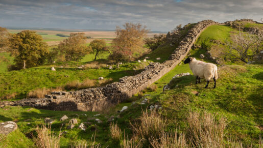
The curtain wall itself was intended to be 76 Roman miles long and to close off the Tyne-Solway isthmus. It was constructed in stone to the east of the River Irthing. Initially built to a gauge of ten Roman feet, the width was subsequently reduced to between six and eight Roman feet. In many places this ‘Narrow Wall’ was built on broader foundations that had already been laid. Between the River Irthing and the Solway Firth the Wall was constructed in turf, 20 Roman feet wide, with a steeper batter on the north side. It is possible that the use of turf was dictated by the relative scarcity of suitable building stone, although at a later date the Turf Wall was rebuilt throughout in stone. The line of the Wall from Newcastle to Chesters was surveyed to run in straight sections between high points; the section from Newcastle to Wallsend was probably added later. From Chesters to Sewingshields the Wall followed a broad crest with extensive views to the north, but between Sewingshields and Walltown the line followed the sinuous crest of the Whin Sill. Through the less dramatic topography of eastern Cumbria the Wall again followed a straighter line between high points.
The Wall does not survive to full height at any point, although at Hare Hill the core stands 3 m high. The faces were constructed of coursed rubble, weakly mortared, and the core was mainly clay bonded. There is no conclusive evidence as to how the top of the Wall was finished. Inscribed stones, of varying degrees of sophistication, recorded the completion of individual sections by the unit involved.
The Wall crossed many streams, but even the substantial bridges that were thrown across the three major rivers – the North Tyne at Chesters, the Irthing to the east of Milecastle 49, and the Eden at Carlisle – were initially limited to pedestrians. The bridges were altered in the second half of the second century to accommodate vehicular traffic using the principal axial route, the Military Way.
A substantial ditch protected the Wall on its north side, except where the natural topography made this superfluous. The dimensions of the ditch vary considerably with the topography and geology. The northern side of the ditch was built up with a carefully constructed artificial bank, known as the counterscarp mound, which also varied in form.
Small fortlets (the ‘milecastles’), approximately 25 m square, with characteristic rounded external corners, were attached to the rear of the Wall at intervals of approximately one Roman mile. Within each of these, a central road. flanked by one or two barracks, linked north and south gateways through the Wall. Of the supposed 80 milecastles, only 58 have been firmly located, and only eight have been largely or fully excavated.
Between each milecastle, two turrets, approximately 6 m square, were attached to the Wall at intervals of a third of a mile.
The western end of the Wall itself seems to have been just to the west of the fort at Bowness-on-Solway, but the defences continued further around the Solway coast. Between Bowness and Moricambe, two parallel ditches are known from aerial photography and excavation, possibly with an associated wooden palisade. To the south of Moricambe, there was no continuous barrier, but there was a series of freestanding fortlets and towers extending beyond Maryport. Forts were also constructed along this coast, at Beckfoot, Maryport, Burrow Walls, Moresby, and Ravenglass. However, the full extent and complexity of the Cumbrian coastal system remains uncertain.
The slight earthworks or cropmarks of more than 60 temporary camps – ranging in size from 17 hectares down to little more than 300 sq m – have been identified between the Tyne and the Solway. These sites reflect a variety of roles, some being thrown up to defend troops in transit, some for those engaged in quarrying or construction over an extended period, or as practice for the troops.
Subsequent Hadrianic Modifications
A major change of plan during the construction of the Wall was to build new forts attached to it. Some replaced earlier turrets and milecastles. At about the same time the curtain wall was extended eastwards for four miles, wholly as Narrow Wall, to Wallsend on the north bank of the River Tyne.
The five eastern forts at Wallsend, Benwell, Rudchester, Halton Chesters and Chesters were all built in stone astride the Wall, facing north. Other new forts, at Housesteads, Great Chesters, Stanwix, Drumburgh, and Bowness-on-Solway were attached to the rear of the curtain wall. There are also at least two forts of different ages known at Burgh-by-Sands, although their dates are not yet confirmed.
A further fort at South Shields stood on the south bank of the Tyne near the mouth of the river. The known fort here dates from the AD 160s and is not therefore Hadrianic. The initial function of this fort was most likely to guard a port at the mouth of the Tyne. It was subsequently expanded to function as a major supply base.
In addition to the forts on the Wall, three forts were built to the north of the western end of the Wall, at Birrens, Netherby, and Bewcastle. Of these, only the latter is formally included in the WHS.
The Vallum, constructed in the same period as the new forts, runs south of the Wall. Its dimensions vary, but a typical stretch might consist of a steep-sided flat-bottomed ditch, 6 m wide and 3 m deep, flanked by two mounds, each 6 m across; there is a third, smaller mound on the south lip of the ditch. The course of the Vallum was surveyed quite independently of the Wall, and the distance between the two linear elements varies, from close proximity to nearly 1 km. The precise purpose of the Vallum is still a subject of debate.
Further modifications were made to the Wall later in Hadrian’s reign. A new fort, approximately halfway between Housesteads and Chesters, was constructed at Carrawburgh, whilst the Stanegate fort at Carvoran and the easternmost five miles of the Turf Wall were rebuilt in stone. Around Birdoswald, the replacement stone Wall was built on a new line up to 200 m to the north of the Turf Wall, with new turrets and a new milecastle. The Wall, as a whole, seems to have been largely abandoned after Hadrian’s death when his successor, Antoninus Pius (reigned AD 138-161), advanced the frontier to the Forth-Clyde isthmus.
Post-Hadrianic Modifications
In the late 150s the Roman army began to withdraw from the Antonine Wall and from southern Scotland. Hadrian’s Wall was re-occupied, and there were further changes. A new metalled road, the Military Way, ran between the Wall and the Vallum (and sometimes on the north mound of the Vallum), connecting all the forts and milecastles. In the late 180s, many of the turrets, especially in the central sector, were evidently seen as superfluous and were abandoned. Some of these were demolished in the early third century. The remainder of the Turf Wall was rebuilt in stone (incorporating the primary stone turrets), as were the turf and timber forts.
In the mid-second century, new outpost forts (on the site of earlier ones) had been established on Dere Street (the Roman road between York and the Antonine Wall) at Risingham, High Rochester, and Newstead.
At the end of the second century, or early in the third, a new fort was added to the Wall at Newcastle, to guard the bridge crossing the River Tyne. The fort on the line of the Wall at Burgh-by-Sands may also have been built at this time although the evidence is uncertain.
Civilian Settlements and Cemeteries
Wherever the Roman army went, civilian settlements (vici) developed outside the forts, initially to the south of the Vallum. Excavation and geophysical survey, and work elsewhere in Roman Britain, suggest that these civilian settlements included a number of official, semi-official, and commercial buildings, as well as domestic accommodation for civilians and veterans.
Cemeteries developed outside the civilian settlements; little is known about them but such remains have been located at South Shields, Great Chesters, Vindolanda, Birdoswald, Nether Denton, and Beckfoot. A considerable number of tombstones survive from the Wall zone, forming an important element in museum collections.
There is strong evidence from the coastal plain in Northumberland that when the Wall was built the settlements of the indigenous population were cleared away for a distance of about ten miles in front of the frontier. This may have been true of other areas also, although finds of Roman pottery from indigenous settlements close to Chesters suggests that the full picture may be complex and needs further work to understand.
Post-Roman Evolution
Following the withdrawal of central Roman authority from Britain, and throughout the medieval period, small, nucleated settlements, with open fields of arable and pasture, developed in the Tyne valley and the Solway basin. Some of these settlements probably grew, directly or indirectly, from Roman sites, as at Corbridge, Newbrough, Stanwix, Burgh-by- Sands, and Bowness.
Inevitably, the Wall served as a quarry for building material. The development of monasticism spurred re-use of the masonry, initially by Anglo-Saxon religious houses at Tynemouth, Jarrow, and Hexham, and in the 12th century by Augustinian foundations. The latter drained the marshes and built sea dykes, as well as clearing woodland.
Settlement in the upland parts of Hadrian’s Wall was more scattered. It has been shown that the fort at Birdoswald – a ready-made defensible and stock-proof enclosure – was occupied periodically over several centuries. One of the Roman granaries there was adapted as an open building not dissimilar to an Anglo- Saxon hall. Elsewhere, further evidence survives for the re-use and adaptation of Roman sites and structures on the Wall, including the Norman motte at Beaumont. Between the 12th and the 15th century, shielings were built along the Whin Sill by the herdsman who were exploiting the upland summer pastures there for their sheep and cattle. Some of these shielings occupied the ruined milecastles, whilst others were built in the shelter of the Wall.
Hadrian’s Wall itself continued to be a prominent feature of the landscape. In the eighth century, Bede described it in his History of the English Church and People, and in the mid-13th century it was still considered sufficiently significant to appear on Matthew Paris’s map of Britain. After his visit in 1599, William Camden described the Wall as almost complete in the upland sections of its course. Documents such as the Lanercost Cartulary and the Hexham Black Book, Lord William Howard’s Survey of the Barony of Gilsland, and the manorial plans of Benwell and Elswick, all show that the line of the Wall was still recognisable in the landscape during the medieval period, and was occasionally used as a property and field boundary, and as a boundary between estates and parishes. The significance of the Wall is also retained in place-names such as Walby, Walton, Walwick, and Thirlwall.
In the late medieval period, the dissolution of the monasteries and the prolonged periods of Anglo- Scottish warfare had a profound effect on society. The period from the 14th to the end of the 16th century saw the building of strong bastle houses, fortified stone towers or ‘peles’, and more substantial castles, such as those as at Triermain, Bewcastle and Thirlwall. The east side of the south gate at Housesteads was converted and extended into a bastle at around this time, and the west gate at Birdoswald was used as a defensive structure. Fortified church towers at Burgh-by-Sands and Newton Arlosh were built to provide refuge to the local populations.
Many of these buildings include within their fabric stone taken from the Roman remains. 36 buildings of an ecclesiastical nature in the region incorporate Roman stone, as do over 30 fortified buildings in the vicinity of the Wall. The castles at Bewcastle and Thirlwall were built almost exclusively of Roman material.
Knowledge of the existence of the Wall played a role in the revival of classical learning in England in the late 16th and early 17th century, and a number of collections of inscribed stones were made at several locations along its length (especially at Naworth, Castlesteads, and Maryport) by local landowners during the 16th to 18th centuries.
The union of the crowns of England and Scotland in 1603, and the Act of Union in 1707, gradually brought a more peaceful Border and the creation of increasing numbers of permanent, undefended settlements. New farmhouses were built and a significant amount of land was improved and enclosed. In the central sector, the Wall was extensively quarried for new houses and field walls, except where the Wall still served as a property boundary.
The construction of the Military Road, in the mid-18th century, improved access and communications across the country, but from Newcastle to Sewingshields it was built mostly on the remains of the Wall itself. Whilst the building of the road reduced the remains further, it also emphasised the route of the Wall and its linear impact in the landscape.
The Military Road and, in the 19th century, the Carlisle-Newcastle railway, opened up the Hadrian’s Wall corridor to economic development. Improved agricultural methods led to field enclosures and land improvement. Many of the farmhouses in the corridor date from this time. In the 20th century, commercial forestry began in the northern perimeter of the central sector of the Wall. Quarrying and mining also made an impact – particularly the quarries at Cawfields and Walltown, which between them destroyed nearly a mile of the Wall. Mining and the railway in the Tyne valley boosted Haydon Bridge, Bardon Mill and Haltwhistle, whilst Gilsland developed as a spa in the 19th century. On Tyneside, and to a lesser extent in Carlisle, the Wall succumbed to urban development and industrialisation.
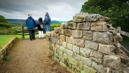
Since the Second World War, the increase in car ownership and leisure, and in the number of sites managed for public access in the WHS, has accelerated the expansion of tourism. Car parks and visitor centres have had an impact on the landscape, but tourism also contributes to the conservation of the WHS and its landscape setting, and to the local economy through the use of local services and businesses.
The further development of technology has brought other elements into the landscape – such as overhead power-lines and masts for mobile telephone networks. The transmission masts near Stagshaw are conspicuous landmarks, and the radio masts at Anthorn are visible throughout the Solway plain, especially at night. Nuclear power has also made a significant impact at Sellafield on the Cumbrian coast and, until its demolition in 2007, the power station at Chapel Cross, near Annan, was the most prominent landmark in the outlook from the Wall along the Solway shore. Its demolition demonstrates how intrusions into the landscape can be relatively temporary. The demand for renewable energy has seen a marked growth in the number of wind turbines visible from the WHS.
In eastern Northumberland, arable farming predominates, and some field boundaries have been removed. In the central area, in west Northumberland, the landscape is largely a 19th-century one, with pastureland, scattered farms, and stone field walls. In Cumbria, the rural landscape to the east of Carlisle is largely derived from late 18th-century re-planning of a late medieval landscape, whilst to the west of the city there are hamlets and small villages with medieval origins, surrounded by 17th-century strip-field enclosures, and late 18th-century enclosures of the bogs and mires.
The urban landscape on Tyneside has evolved from its medieval form through dramatic periods of expansion and industrialisation in the 19th and 20th centuries, to lighter, post-industrial redevelopment. In the centre of Carlisle, the urban landscape retains much of its 18th-century character; further out there was notable 19th-century industrial growth and later 20th-century development.
THE SURVIVAL AND CONDITION OF THE RESOURCE
The development of the landscape has included several episodes that have affected the survival of Hadrian’s Wall. The Roman remains were freely plundered for stone to build churches, castles, field walls and farmhouses, and more intensive agricultural improvements have in places reduced the earthwork components such as the Vallum and temporary camps. Other developments, such as urban and suburban expansion, have levelled but not totally destroyed the archaeological remains. The 18th-century Military Road both masks and protects the physical remains of the Wall itself. Overall, the survival of the various elements of the Roman frontier varies considerably across the WHS.
The Urban Areas
In the urban areas of Tyneside and Carlisle, the buried remains of the frontier have often survived remarkably well. Some of the visible elements are those that received the attentions of the early conservationists – for example, the remains of the fort and supply base of Arbeia and the short length of Wall and Turret 7b at Denton. (Despite the buildings that eventually covered it, the depth of stratigraphy over most of the interior of Arbeia showss that the degree of survival can equal that in rural areas.) In Newcastle, the south-west corner of the Westgate Road milecastle had survived and was only discovered by chance during development. The length of Hadrian’s Wall that has been exposed in Buddle Street, Wallsend, stands up to eight courses high and exhibits excellent evidence of the sequence of partial collapse, repair and reinforcement.
Elsewhere, dumped industrial waste and post-medieval building have preserved the remains from robbing – for instance, the bath-house at Wallsend – a cause of destruction which in many rural areas continued until relatively recent times.
The urban areas are most prone to pressure from development and infrastructure works. This is most acute where the line is intersected by, and underlies, the urban service network. The need to repair and enhance utility supplies has inevitably been destructive but has also resulted in a number of archaeological interventions and consequent discoveries as well as increased understanding; some of these have revealed important evidence relating to the construction of the Wall and its foundations, noted the presence of pits for defensive entanglements on the berm between the curtain wall and the ditch for the first time, and the line and position of the Vallum.
The Rural Areas
In east Northumberland, and in Cumbria to the west of Brampton, many archaeological sites, including the Vallum and temporary camps, are under intensive cultivation, either annually or in rotation. This has reduced, and in parts entirely removed, the surface indications, but significant remains can still survive beneath the ploughing. A significant area that may still be at risk from ploughing is the major part of the Roman town at Corbridge.
None of the forts on the Wall is now under regular arable cultivation, although parts of the associated civilian settlements are subject to ploughing, particularly to the west of Halton Chesters and to the south of both Great Chesters and Castlesteads. Although some milecastles have been extensively damaged, the investigation of 12 of them in cultivated areas found only two that were being actively damaged by ploughing. The remaining ten had reached a level of stable survival below the plough soil. In places, cultivation has actually built up a cushioning layer of soil.
Details of the two forts south of the Wall at Burgh-by- Sands and the coastal fort at Beckfoot show well as crop-marks in appropriate conditions, as do those temporary camps that are under cultivation.
In the central sector, remains are generally much better preserved, partly because the upland nature of the land has not lent itself to intensive cultivation over the last century. Today the land is primarily used for stock rearing and grazing. In some places, the Wall has been preserved as a field and property boundary, which may account for its survival.
Almost all of the visible Roman masonry in the WHS has been cleared and consolidated over the last 150 years. One of the strikingly visible lengths of the Wall in the central sector, between Steel Rigg and Housesteads, is a 19th- and 20th -century restoration designed to protect the intact Roman remains. Here, the faces are built up as dry-stone walling, re-using Roman facing-stones around the original Roman core (the so-called ‘Clayton Wall’). Elsewhere, stone field-walls on the line of the Wall stand on the Roman foundations. Where a soil mound covers the Wall, the masonry and the evidence for its collapse in the surrounding tumble survive well.
The earthwork components are also well preserved in the central sector. The Vallum is spectacularly preserved in places, particularly between Blackcarts and Sewingshields, and at Shield-on-the-Wall, where they stand between one and two metres high. Most of the temporary camps in the central sector survive as upstanding earthworks and the details of their entrances and perimeters are clearly visible. The group around the Caw Burn on Haltwhistle Common, is particularly well preserved. The unimproved and semi-improved pasture in this area has helped to preserve even the subtlest of features, such as a group of Roman barrows to the south of Great Chesters. Considerable lengths of the remarkable seven-mile aqueduct that served Great Chesters (a narrow channel 0. 5 m wide and 0.3 m deep, with a retaining bank on the downhill side) survive to the north of the fort. The earthworks of this subtle feature would be levelled by a single ploughing, as has happened where improvement of pasture has occurred elsewhere along its length.
On the Solway coast, apart from the earthworks of the forts at Maryport and Moresby, and the displayed milefortlet at Swarthy Hill, the sites of the forts, milefortlets and towers are mainly known from excavation or aerial survey. Between Bowness and Moricambe two parallel ditches are known from aerial photography and excavation: these may have had an associated wooden palisade. However, south of Moricambe, there was no continuous barrier. Forts were constructed at Beckfoot, Maryport, Burrow Walls, Moresby, and Ravenglass, but the precise extent and composition of the Cumberland coastal system is uncertain; the milefortlets and towers have only been traced as far as Flimby, just to the south of Maryport.
There is considerable variation in the degree of survival of the ‘positive’ linear elements of the frontier: the Wall itself, the counterscarp bank, the Military Way, and the Vallum. However the ‘negative’ features, such as the substantial ditches of the Wall and Vallum, probably survive below ground for most of their length. The Wall ditch is intermittently visible to some degree from the western edge of Newcastle and is a prominent feature (where it was provided) from Heddon-on-the-Wall westwards to Banks, together with its counterscarp bank. After that it is visible intermittently, sometimes just as a shallow depression.
Forts
Of the 16 forts along the line of the Wall and the supply-base at South Shields, only one (Benwell) has been partially destroyed – by a reservoir on its north side. Its southern part is built over, as are significant areas of a further five forts. The surviving archaeological potential of these is still considerable.
The remaining ten forts on the Wall are totally or mostly unencumbered by buildings. They survive either as substantial earthworks with buried masonry, or as consolidated remains, as at Chesters, Housesteads, Great Chesters and Birdoswald.
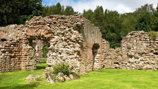
Of the Stanegate forts (apart from Corbridge), the most significant survival is at Vindolanda where the remains of the later stone forts are well preserved: several buildings, and the fort walls, have been exposed and consolidated. Here, as at Carlisle, the anaerobic conditions have preserved structural timbers of the pre-Hadrianic forts, as well as a richness of organic finds apparently unparalleled elsewhere in the WHS.
The structures in the six-sided fort at Bewcastle were shown through excavations between 1938 and 1978 to survive well as buried remains within the earthworks of the fort defences, despite the subsequent construction of the medieval castle, the church and churchyard, and a working farm. Geophysical survey has also shown further remains surviving outside the fort, although it is not certain how many of these are of Roman date.
On the Cumbrian coast, Beckfoot, Maryport and Ravenglass survive as substantial earthworks, whilst the rampart of the fort at Moresby is also visible west of the churchyard.
Extramural Civilian Settlements and Cemeteries
The condition of the extramural settlements and cemeteries of these forts is largely unknown, as few have been investigated by excavation until recent years and a number of them lie under modern towns and villages.
There have been excellent results from geophysical surveys covering the civilian settlements at Halton Chesters, Chesters, Housesteads, Carvoran, Birdoswald, Castlesteads, Beckfoot, and Maryport.
In very few cases, including Great Chesters, Castlesteads and Halton Chesters, are parts of the settlement under cultivation, although at Castlesteads the southern part is subject only to occasional ploughing
A significant part of the settlement at Vindolanda has been excavated and consolidated, along with early-20th-century excavations of Corbridge’s fort phase. In more recent years a series of excavations on the extramural settlements at Benwell, Birdoswald, South Shields, Stanwix, Maryport, and early phases at Carlisle have started to develop understanding of this class of site. These works suggest that for much of the Wall there is a clear potential for good preservation of the extramural settlements.
Roman Urban Areas
Corbridge, the only Roman urban centre within the WHS, has been damaged relatively little by modern development, apart from losses to its northern edge caused by the construction of the A69. Its central area was excavated and is displayed for public access; the remainder is mostly under cultivation and may be at risk. Carlisle, the other main Roman urban centre associated with the WHS, has demonstrated enormous archaeological potential: the site has deep stratigraphy, well-preserved remains of both the stone and of the timber phases, and waterlogged deposits that contain important environmental and scientific evidence.
Destruction
Total destruction of the Roman remains is only likely to have occurred in limited areas, in particular:
- where the frontier line has been crossed by new roads (e.g. the A1 Newcastle western bypass, the dualling of the A69, and the M6 motorway) and oil and gas pipelines;
- Benwell reservoir, which occupies the northern half of the site of the Roman fort;
- quarrying, including major interventions at Walltown and Cawfields;
- coastal erosion, which has probably destroyed the milefortlets and towers around Allonby Bay, and which still threatens the Roman cemetery associated with the fort at Beckfoot, and the western part of the fort at Ravenglass;
- riverine erosion, as at Corbridge and Willowford;
- the former mineral railway that bisected the fort of Burrow Walls, and the coastal railway from Carlisle to Barrow-in-Furness which cuts through the fort at Ravenglass;
- the 18th-century canal from Carlisle to Port Carlisle, which cut across the frontier in several places.
Acquisition and Preservation
The increasing pace of destruction of Hadrian’s Wall in the 19th century was matched by growing interest in its study and conservation. Antiquarians such as William Camden, in the early 17th century, and John Horsley in the 18th century recorded what survived at that time. William Hutton saved the Wall at Planetrees from being taken apart for field walls in 1801. Rev Anthony Hedley acquired the site of Chesterholm (Vindolanda) in 1829. Later in the 19th century, John Clayton bought land on the line of the Wall in the central sector. He partially reconstructed lengths of the Wall between Steel Rigg and Housesteads and carried out associated excavations. The first decennial ‘Pilgrimage’ along Hadrian’s Wall, in 1849, spurred further excavation and study.
The creation of the Roman Remains Park, in 1875, by South Shields Urban District Council, as a result of discoveries made during development of the area for housing, marked the first deliberate display of part of the WHS by a public body.
The Hadrian’s Wall and Vallum Preservation Scheme (drawn up in 1931 but only confirmed in 1943) brought a marked increase in the proportion of the remains that were protected by statute (‘Scheduling’). The further extension of these powers, under the provisions of the 1979 Ancient Monuments and Archaeological Areas Act, provides the basis for the scheduling of the frontier, and thus the definition of the WHS.
The National Trust was given the nucleus of its Hadrian’s Wall estate in 1930 and, from 1932 onwards, parts of the Wall have come into state care – under Guardianship arrangements in which legal title is retained by the landowner.
Public ownership of sections of the frontier includes: the fort at Wallsend which was acquired by North Tyneside Council; the fort at Birdoswald, acquired by Cumberland County Council and subsequently transferred to English Heritage; Milefortlet 21 (Cumberland Council); and a length of the Wall at West Denton (Newcastle City Council).
Chesterholm (Vindolanda) was purchased by Eric Birley in 1929; this was followed by the establishment of the Vindolanda Trust in 1970, and its acquisition of the fort at Carvoran. In 2008, the fort and the vicus at Maryport were acquired by Hadrian’s Wall Heritage Ltd in order to safeguard the land, to make it accessible, to conduct further excavations, and to open a new visitor centre and museum in the buildings at Camp Farm. In 2015 ownership of Camp Farm was transferred to the Cultura Trust.
The establishment, in 1956, of the Northumberland National Park, which includes the central sector of Hadrian’s Wall from Carvoran to Tower Tye, has added to the cause of conservation and to the appreciation and enjoyment of both the heritage and the landscape.
RESEARCH AND EXCAVATION
In the late 16th century, antiquaries began to record their visits to the Wall, and from the 18th century the frontier was mapped in detail.
Archaeological excavations began in the 19th century and have continued to the present day. In the 19th century, excavations took place at (inter alia) Chesters, promoted by Clayton, at Housesteads by Robert Carr Bosanquet, at Great Chesters by Rev G R Hall and by J P Gibson, and at Chesterholm (Vindolanda) by Rev. Anthony Hedley. From the 1890s to the 1930s, much effort was made to understand the various elements of the frontier.
Since the Second World War excavations have been conducted at the forts at Bowness, Burgh-by-Sands, Carlisle, Birdoswald, Vindolanda, Housesteads, Corbridge, Rudchester, Benwell, Newcastle, Wallsend, and South Shields. Milecastle 35 (Sewingshields) has been wholly excavated and displayed under modern archaeological control, and the interior of Milecastle 39 was excavated and displayed in the 1980s. Eleven milecastles were selectively excavated by English Heritage in 1999-2000, to assess their survival. Of the Turrets and analogous structures, only the additional tower in Peel Gap has been excavated in the past 30 years.
A number of other modern excavations have been carried out where the remains have been investigated in advance of development but have not been displayed. These include:
- Bowness-on-Solway, in advance of new housing;
- Bewcastle, in advance of new agricultural buildings and an extension of the cemetery;
- Corbridge Red House, in advance of the A69 Corbridge bypass;
- Various sites within urban Tyneside, including Benwell, Newcastle, and Wallsend
Excavations were carried out at Ravenglass in the late 1970s in advance of coastal erosion, and in 2013-14 on the extra-mural settlement. Excavations in the civil settlement and temple area at Maryport began in 2012.
The major research programme continues at Vindolanda with annual excavations and continuous post-excavation analysis, conservation and publication, whilst the Trust’s excavations designed to understand changes to the site at Carvoran, potentially tied to climate change, began in 2023.
Aerial photography, which was first effectively used along the Wall in the 1930s and became increasingly important after 1945, has helped to define the frontier works and has led to many new discoveries. The development of geophysical survey revolutionised existing knowledge by identifying extensive civilian settlements outside several forts. More recently, the use and accessibility of Lidar has revealed important details of the earthworks of the frontier, including a number of camps, hitherto undiscovered.
The National Mapping Programme, undertaken by English Heritage, has recorded all of the features that were visible on aerial photographs of the Wall corridor up until 2009. One key finding was the number of relevant archaeological sites in the immediate area.
This information, which shows the populated nature of the landscape through which the Wall was constructed, has been used in the mapping of the Roman frontier. The English Heritage Archaeological Map of Hadrian’s Wall, a completely new compilation, was published by English Heritage in 2010; a second edition appeared in 2014, and is now published under the Historic England imprint
Community archaeology has grown apace in the UK and has yielded important new information on Tyneside, including the excavation of the bath-house of the fort at Wallsend, work done by the WallCAP project at Corbridge, and excavation on the monumental building at Stanwix.
Research is also being undertaken into the study of Hadrian’s Wall by previous generations, in order to understand changing interpretations of its function and purpose, its place in the history of Britain, and the roles that it has played in culture, art, and politics.
The Resource Assessment volume of the research framework for the Wall, published in 2009, includes a review of the state of research.
As a result of all of this activity, Hadrian’s Wall is one of the most extensively excavated of the frontiers of the Roman Empire, and almost all the original above-ground masonry visible today is the result of excavation. Nevertheless:
- only 159 m of the curtain wall, approximately 0.13% of the total length, has been excavated under modern conditions and consolidated since the late 1970s;
- 6,055 m (5%) was cleared without archaeological supervision or recording under the Ministry of Public Works programme of the mid-20th century;
- 2,416m (2%) is the result of 19th-century restoration (the ‘Clayton Wall’ in the central sector);
- 108,210m (91%) of the curtain wall is not visible but survives (to varying degrees) as buried remains; much of it is under the B6318 Military Road, or survives as upstanding earthwork remains, while in Cumbria substantial lengths survive under the banks of field boundaries.
Hadrian’s Wall has been fortunate to have a wealth of publications written on numerous aspects of its archaeology, history and preservation.
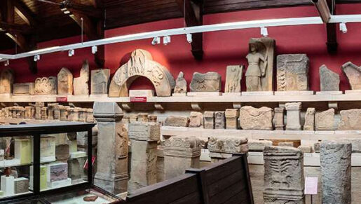
Finds and Collections
Antiquarian pursuits and archaeological excavation have collected together a huge assemblage of artefacts that illustrate the life of the Wall in the Roman period. While some survive in private collections, and others are in museums elsewhere in the United Kingdom (in particular the British Museum), most are housed in the principal museum collections directly associated with the Wall. These include the Great North Museum in Newcastle; Tullie House, in Carlisle, and site museums at Arbeia, Wallsend, Corbridge, Chesters, Housesteads, and Vindolanda.
The artefacts in these collections are no longer in situ, and so they are not technically part of the WHS itself. However, this exceptionally large assemblage is essential to the understanding of the frontier. A large number of the artefacts from the Wall have been published, particularly in the last 20 years.
The text found on some of the building inscriptions, and on altars, identifies the names and country of origin of units occupying the forts at certain dates, and a number of inscriptions confirm the Roman name of the site where they were found.
Excavations at Vindolanda have revealed an unparalleled collection of writing tablets, preserved in anaerobic conditions, ranging from official documents to personal correspondence. The information on the tablets contributes significantly to understanding of the context of Hadrian’s Wall. Although these documents are from a generation earlier than the building of the Wall itself, they can be presumed to reflect aspects of life along the frontier. Other tablets have been found in Carlisle. Taken together, the inscriptions and writing tablets form the largest collection of written Latin from the Roman world outside Italy.
Anaerobic conditions at Vindolanda and Carlisle have also produced large quantities of shoes, other leather items, cloth and wood, whilst extensive finds of pottery across the Site illustrate not only cooking and eating habits, but also the trade patterns by which the Wall was supplied.
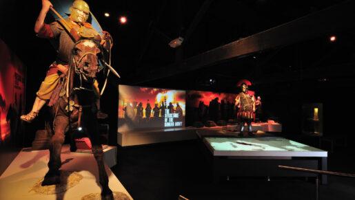
Not surprisingly, the WHS has yielded significant assemblages of Roman military equipment, including the important Corbridge hoard of armour.
Material from native settlement sites to the north of the Wall represents the largest assemblage of material from Rome’s immediate protagonists within a frontier zone. Along the frontier itself, many objects associated with religion attest to the interaction of Roman and native cultural traditions, in particular the equating of Roman gods and goddesses with native deities.
Inscriptions, coins, and pottery from excavations on the Wall constitute very significant evidence for dating the construction, alteration, and final abandonment or demolition of buildings on the frontier, and form the archaeological basis for the chronology of the WHS.
Secondary Sources
Another valuable resource is the body of archive material that has been assembled relating to the WHS. In the case of excavation records, the archive is often the only record of that part of the Site now available for research.
Other secondary sources are of value, particularly those that record aspects of the Site that have changed since they were compiled. The collections of the Society of Antiquaries of Newcastle, housed in the Great North Museum, include aerial and other photographic archives of the WHS. Other significant archival collections are located elsewhere, particularly at Cambridge University and in the Historic England Archive in Swindon.
Antiquarian illustrations were frequently accurate in their detail. Several important collections show parts of the Site at specific times or record objects, particularly inscriptions, which have since been lost. Vindolanda holds the archives of Eric Birley, and much of those generated by Charles Anderson (who cleared and consolidated lengths of the Wall for the Ministry of Works), and part of the John Mann archives.
Source Material for Scientific Analysis
Many collections contain not only artefactual material, but also material that is still available for scientific analysis – a factor of increasing importance.
- Pollen and faunal remains from deposits such as the fill of ditches and from occupation layers, can provide evidence of the environment and landscape at the time they were constructed, occupied or abandoned.
- Pollen samples from other nearby sources, such as peat deposits and mires, can provide significant comparative material.
- Food residues on pottery can reveal information about the diet of the army on the Wall, as can deposits associated with granaries, and where human waste has collected.
- Scientific analysis can contribute to an understanding of the technologies employed by the army on the Wall.
- Colleagues in Germany have undertaken research on the mortar used to construct the Wall.