The History of the Wall
Start Exploring
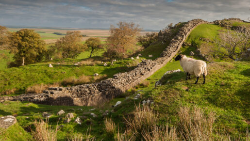
A World Heritage Site since 1987, Hadrian’s Wall is an astounding feat of engineering. It’s the best known and the best preserved frontier of the Roman Empire. When Hadrian’s men set out to construct it they were faced with a relentlessly challenging and variable landscape to conquer. Not the fierce torrents of fast rivers, the hard rock of the Whin Sill, nor mile upon mile of rolling hills would defeat them. The Wall is Britain’s most impressive and most important Roman monument. Together with the Antonine Wall and the Upper German Raetian Limes, it forms part of the UNESCO World Heritage Site ‘Frontiers of the Roman Empire.’
When was the wall built?
On becoming Roman Emperor in 117AD, Hadrian set about making the Empire more secure, separating Roman and Barbarian territories. The most spectacular example of this is the great Wall he ordered his army to build to define the north-west frontier of the Roman Empire. It was a gargantuan task which he came to inspect in AD122 while work was in progress. The Wall sprawled across 73 miles from Wallsend in the east to the Solway Firth in the west. Although the curtain Wall itself finished at the Solway Firth, its forts, milecastles and turrets continued down the Cumbrian coast to Maryport with further forts marking the miles beyond to Ravenglass.
Why was it built?
Hadrian visited Britain in AD122 and, according to his biographer, writing two centuries later, was ‘the first to build a Wall 80 miles long from sea to sea to separate the Romans from the barbarians’.
In that way, a function, probably the chief function, of the Wall, was frontier control, just like modern frontier barriers. Here, the army enforced the regulations which governed access to the empire. It would appear, from comments about other frontiers, that people could only enter the empire at designated points and travel unarmed and under military escort to specified markets or other places. The Wall would also help to prevent raiding which we know happened on all frontiers. The purpose of the auxilliary units based in the frontier area was entirely different; it was military defence – as well as the protection and policing of the provincials. The placing of forts on the line of the Wall obscured the difference between these two functions. Analysis of the location of the Wall in the landscape indicates that it was not always placed in the best position if defence was the main criterion.
It may also be considered that the Wall formed but one part of a wider system of frontier control. Cavalry are attested at many forts on the line of the Wall. To use these soldiers as frontier guards would be a waste of their skills; it is more likely that they patrolled the area to the north. Certainly later scouting to the north of the Wall is attested as well as treaties between the Romans and their northern neighbours.
How did they build it?
It’s thought to have taken three legions of infantrymen from the army of Britain around six years to complete the Wall. Each legion was around 5,000 men strong. The legionary soldiers were responsible for major construction tasks like building stone forts and bridges. Extra man-power may have been provided by soldiers from auxiliary regiments recruited from allied and conquered tribes who supported the legions in battle and garrisoned the frontier forts.
The building of Hadrian’s Wall was a complicated process, containing several changes of plan. The first scheme was for a wall of stone 10 Roman feet (3m) wide from the River Tyne westwards for 72km to the River Irthing and a turf rampart 20 Roman feet (6m) wide for the western 45km from the Irthing to the Solway Estuary. The builders made good use of local geographical features. The well-known central sector, actually only about 20km long, ran along the crags, but to the east the Wall was placed on a long ridge running eastwards to Newcastle, while to the west the Wall was often located on shorter ridges, all normally giving wide views to the north.
The stone wall was probably planned to be 15 Roman feet (4.4m) high. It had dressed facing stones in a soft mortar and a core of earth or clay with stones. There is some evidence that there was a wall-walk and parapet along its top.
In front of the Wall lay a berm, normally about 20 Roman feet (6m) wide. In places in the eastern 17.5km of the Wall pits have been found on the berm. In one area at least, where there were three rows of pits, each held two substantial posts, perhaps cut down tree trunks with the branches trimmed short and sharpened at their ends. In one sector the pits were recut. Beyond the berm lay a ditch. It ran along the whole length of the Wall, except where the crags or similar features rendered it unnecessary. It was probably planned to be 30 Roman feet (9m) wide. The material from its excavation was tipped out to the north to form a wide, low mound.
At every mile along the wall was placed a gate protected by a small fortlet termed a milecastle. The milecastles were of stone on the stone wall and turf and timber on the turf sector. Most of the excavated milecastles held one building, presumably a barrack-block, probably for about 8 men. Two milecastles appear to have held two double-sized such buildings suggesting a larger garrison. Some milecastles contained hearths and an oven, while in one a staircase leading to the top of the milecastle wall has been found.
Between each pair of milecastles lay two towers, called turrets. These were always built of stone. A platform on the ground floor was presumably the base for a stair or, less likely, a ladder. The primary purpose of the soldiers based in each turret was presumably observation, and therefore there should have been a tower over the north gate of each milecastle. The placing of the door on the ground floor of the turret suggests that security was not an important concern.
The first plan for Hadrian’s Wall was not completed before a major change was made. At intervals of about 11.2km a fort was placed on the Wall. It would appear that wherever possible the intention was to place the fort astride the Wall with three of its gates north of the linear barrier and one to the south. Moreover, all these gates were, unusually, double portal with the rearward gate supplemented by two single-portal side gates. The effect of this positioning was to improve the mobility of the army in the frontier area. This decision was not taken lightly for it involved the demolition of sectors of the Wall, turrets and even a milecastle already constructed and the in-filling of lengths of ditch, while many forts in Wales and northern Britain were abandoned to provide troops for the new forts on the Wall.
At about the same time another significant change was made, the construction of a great earthwork, known since the time of the Venerable Bede writing in about 730 as the Vallum, behind the Wall from Newcastle to Bowness-on-Solway. It consisted of a central ditch with a mound set back on each side. It formed a formidable obstacle and perhaps should have been seen as the Roman equivalent of barbed-wire protecting the rear of the frontier zone. Now crossing the frontier was only possible at a fort where the access point, a causeway, was surmounted by a gate. The number of points where the frontier complex could be crossed was reduced from about 80 to about 16.
There were further changes to the Wall, but of a different character. The width of the Wall was reduced from 10 Roman feet (3m) to sometimes as little as 6 feet (1.8m). There was also a clear decline in standards of craftsmanship with later structures much more shoddily finished off than earlier ones. It is difficult to know when Hadrian’s Wall was completed. An inscription suggests that one fort was not finished until after 128. Nearly ten years later, the fort at Carvoran was being repaired or rebuilt, though this was not a normal Wall fort. Also before the end of Hadrian’s reign, a start had been made on replacing turf wall in stone, though by this time only 8km had been built.
What did the finished wall look like?
Once built, Hadrian’s Wall boasted 80 milecastles, numerous observation towers and 17 larger forts. Punctuating every stretch of Wall between the milecastles were two towers so that observation points were created at every third of a mile. Constructed mainly from stone and in parts initially from turf, the Wall was six metres high in places and up to three metres deep. All along the south face of the Wall, if there was no river or crag to provide extra defense, a deep ditch called the Vallum was dug. In some areas the Vallum was dug from solid rock.
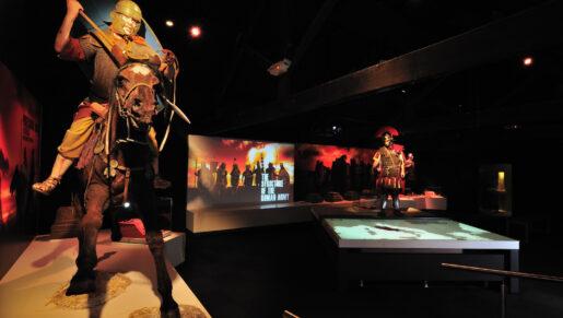
What was life like on the Wall?
The Wall was an active military line for some 300 years with regiments of men from the auxiliary army’s infantry or cavalry manning each fort. Units are thought to have been 500 or 1000 men strong. Camps of people would accompany each unit, although little is known of these communities and they weren’t permitted to settle between the Wall and the ditch (or Vallum) that ran along its length. These communities (called Vicus) provided the best of local produce and goods from around the empire so life was rich for soldiers with pay to spend. When the Rome gave up Britain, the Wall’s stones were repurposed to build homes and other buildings.
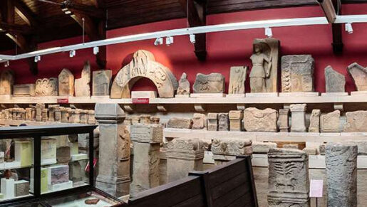
What can you see today?
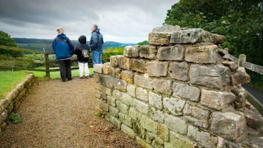
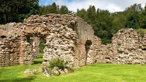
Visitors can still patrol Hadrian’s Wall, which remains standing in many areas. Housesteads is one of the Wall’s best-preserved forts with the foundations of a hospital, barracks and flushable loos still visible. At Heddon-on-the-Wall meanwhile, a vast chunk of the frontier still stands, heading east into the busy city of Newcastle, while the ruins of the Roman bridge that traversed the Wall’s route across the River Irthing remain.
Facts about Hadrian’s Wall
Much of what is now Scotland was occupied or controlled by the Romans for over 300 years. Roman armies first invaded this area in the AD70s, some 50 years before Hadrian’s Wall was built. Hadrian’s Wall itself was abandoned only 25 years after it was built and a new turf and timber wall was constructed on the edge of the Scottish Highlands – the Antonine Wall. After another 25 years Hadrian’s Wall was re-established as the frontier line. In the early third century the African Emperor Severus led a vast army north of Hadrian’s Wall. He died in York and his sons made a peace with local tribes which lasted for a hundred years. Many of the forts along Hadrian’s Wall continued to be occupied into the fifth and sixth centuries AD, long after Roman Imperial rule in Britain had ended.
It’s sometimes mistakenly thought that the Wall marks the English/Scottish border. In fact, Northumberland, England’s largest county, lies mainly north of Hadrian’s Wall.
Why was Hadrian’s Wall built?
Roman conquest of Britain began in earnest in AD43 when Emperor Claudius’s four legion army captured the southern territories and made them part of the Roman Empire. By AD85 the Romans had pushed northwards into what is now Scotland and defeated the northern tribes at the battle of Mons Graupius.
Following the withdrawal of one of the four legions assisting the Emperor Trajan in his war with the Dacians (modern Romania) a frontier road, the Stanegate, was established where the land narrows between the Tyne to the east and the Solway to the west. A line of forts was established along the Stanegate, including an important base at Vindolanda. In AD117 Emperor Hadrian came to power and determined to consolidate the Roman frontiers. Construction of Hadrian’s intensely ambitious boundary probably began early in his reign and he came to inspect the work in progress in AD122.
Building the Wall took three legions of men at least six years to complete. The scale of the Wall’s design was epic. Hadrian’s original plan set out that the Wall would be made of stone or turf, that it would be a maximum 4.6 metres high and approximately 3 metres deep, and that it would cover a total of 84 miles Roman miles from one sea to the other. Along the Wall, each mile was marked by a milecastle, or small fort, and between each pair of milecastles two towers, or turrets, were built at every third of a mile interval. A number of extra forts on the line of the Wall itself were a late addition to Hadrian’s original plan, and were perhaps ordered by him when he visited in AD122. These forts were set around 7 miles apart along the Wall, straddling it where the land would allow.
Where the Wall finished, this network of forts continued down to Ravenglass on the Cumbrian coast. Another feature that was introduced after the original designs were completed was a 6-metre deep ditch called the Vallum. This extra defence ran parallel to the Wall’s southern side, protecting the Romans from a rear attack and it is still visible today along much of the route.
After Emperor Hadrian
When Hadrian died in AD138, the new emperor, Antoninus Pius, pushed the frontier north to run between the Forth and the Clyde. However, occupation of the Antonine Wall lasted only around 25 years before the Romans returned to refurbish and restore Hadrian’s Wall. They did not restore the Vallum, which suggests that the area around Hadrian’s Wall had been pacified by this time.
Having been erected by legionaries, the Wall was manned by auxiliary units recruited from every corner of the empire, each garrison numbering between 500 and 1000 men. It’s thought that each fort along the route was designed to house a singe auxiliary unit, which would have comprised either infantry or cavalry soldiers, or both. Cavalry forts were established at key locations near river crossings or where major roads crossed the line of the Wall. Communities of merchants, traders and camp followers were established close to the forts. These settlements would have been home to a cosmopolitan mix of locals and incomers from across the Empire, including retired soldiers, serving soldiers’ dependents, and individuals who made a living from servicing the fort – everyone from blacksmiths and food-vendors to innkeepers and sex workers.
Hadrian’s Wall after the Romans
Although details are scarce regarding the Wall’s 300-year active lifespan, historical sources suggest that frontier battles and skirmishes occurred from time to time during the late second and early third centuries AD with a major uprising not long after AD180. The Emperor Septimius Severus brought a vast army to Britain in AD 208 and campaigned far north of Hadrian’s Wall. He fell ill and died in York in AD 211. His sons made a peace with the northern tribes that seems to have lasted for over 100 years.
When Roman Imperial rule over Britain ended in the early fifth century, many of the forts along Hadrian’s Wall continued to be occupied through the fifth and into the sixth centuries AD. The fort commanders and their soldiers appear to have taken responsibility for local security.
The Wall seems to have survived in a reasonable state of preservation into the Elizabethan period of the 16th century when there were even proposals to rebuild it due to the ongoing tension and conflict with Scotland and the lack of security created by the lawless Border Reivers. From this period though, stone from the Wall was increasingly taken and used to build houses, churches and farms across Cumbria, Northumberland and Tyne & Wear. In the 1800s people interested in antiquities began to speak out and prevent this from happening. By the mid-19th century, momentum behind the drive to preserve the Wall had grown and Victorian archaeologists and historians began to contribute to an understanding of the Roman frontier that continues to grow today.