Values
Start Exploring
THE OUTSTANDING UNIVERSAL VALUE OF HADRIAN’S WALL
In order to be inscribed as a WHS, a site must be judged to have Outstanding Universal Value (OUV). The protection and enhancement of this OUV forms the basis for the management of the WHS. At inscription, each site’s individual OUV is now described by a Statement of Outstanding Value (a statement of significance), which must include:
- one or more of the ten criteria for selection (six cultural and four natural) established by the UNESCO World Heritage Committee
- assessments of the Site’s integrity and authenticity
- assessments of the arrangements for protection and management of the Site.
It is then the responsibility of the government of that country to protect, conserve, present and transmit the values of that site to future generations.
Inscription as Hadrian’s Wall WHS
When Hadrian’s Wall was inscribed in 1987 it was considered to meet three of the six criteria established for cultural sites. These were that it should:
(ii) exhibit an important interchange of human values, over a span of time or within a cultural area of the world, on developments in architecture or technology, monumental arts or town planning and landscape design
(iii) bear a unique or at least exceptional testimony to a cultural tradition or to a civilisation which is living or has disappeared
(iv) be an outstanding example of a type of building or architectural or technological ensemble or landscape which illustrates [a] significant stage [s] in human history.
No formal statement of OUV was agreed at that time, though ICOMOS did suggest citations for each of the criteria listed. During the last plan period UNESCO asked all States Parties to provide retrospective Statements of Outstanding Universal Value for properties inscribed earlier. These Statements have to be approved by the World Heritage Committee and must be based on documentation considered by the Committee at the time of inscription. Any change in that assessment would need to be agreed anew by the Committee through a re-nomination of the property.
Inclusion as a Part of the Frontiers of the Roman Empire WHS (FRE)
When the new transnational Frontiers of the Roman Empire WHS was inscribed in 2005 it was considered to meet the same three criteria against which Hadrian’s Wall had been inscribed.
With the inscription of the German Limes as an extension of the Hadrian’s Wall WHS, and the adoption of the name of Frontiers of the Roman Empire, in 2004, an overall Summary Statement of Significance was submitted. This statement was endorsed by ICOMOS International in their assessment of the nomination dossier but reference to it was not included in the decision of the UNESCO World Heritage Committee.
The Statement of Outstanding Universal Value (SOUV) for the FRE and for Hadrian’s Wall
As for all other State Parties responsible for properties inscribed before 2007, The United Kingdom and Germany were required to provide a Statement of Outstanding Universal Value for the Frontiers of the Roman Empire WHS. This was submitted to the World Heritage Centre in February 2012, having previously been prepared by the Co-ordinators of Hadrian’s Wall, the German Limes, and the Antonine Wall, for review by ICOMOS and the World Heritage Centre.
The draft Statement has yet to be accepted by the World Heritage Centre and endorsed by the World Heritage Committee. The text that follows is the draft that was submitted to the World Heritage Centre. The draft Statement of Significance for Hadrian’s Wall attached to the draft SOUV is a useful distillation of the original ICOMOS assessment of Hadrian’s Wall at the time that the property was inscribed on the World Heritage List.
THE VALUES OF HADRIAN’S WALL
Complexity
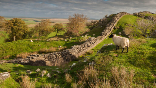
Hadrian’s Wall demonstrates the evolving thoughts of the Roman army on frontier design over 300 years. For Hadrian’s Wall, this began with the line of forts established along the Stanegate under the Emperor Trajan. The first design for a continuous wall with milecastles and turrets, with the main garrisons stationed in pre-existing forts to the south, was modified during construction. Sixteen new forts, several of which replaced milecastles or turrets that had already been built, were constructed on the line of the Wall. The unique Vallumwas added to the south, creating a controlled military zone. Later changes included a new road, the Military Way, connecting the forts, milecastles and turrets, the demolition of a number of turrets, and the rebuilding of the turf and timber structures in stone. Associated sites included civilian settlements, cemeteries, temples and other military works such as temporary camps, aqueducts, quarries and watch and/or signal towers.
The Antonine Wall, built yet further north by the Roman army on the orders of the Emperor Antoninus Pius following the Roman victory over its northern enemies in AD 142, was abandoned in the AD 160s. At the withdrawal of the garrisons from the Antonine Wall, Hadrian’s Wall was recommissioned. The modifications to it – such as the abandonment of the Vallum, the provision of the Military Way, the reduction of the regularity and number of turrets, and the narrowing of many milecastle gates – reflected a further stage in the development of the frontier.
Although the Wall marked the frontier of the province, Roman military activity extended beyond it. In the early third century, four forts north of the Wall contained mixed garrisons of infantry, cavalry and scouts, a thousand strong, which attest to the imposition of Roman power beyond the line of the Wall. These forts were abandoned in the early fourth century, after which the effectiveness of Roman control north of the linear frontier is uncertain.
Group Value
The group value is high, as the individual sites described above are inter-related, both spatially and functionally. This includes the clustering of civilian settlements around forts, and the initial exclusion of civilian structures from the area between the Wall and the Vallum. The group value also includes the visual and spatial relationship between the Wall and the Vallum, and between the Wall and the Stanegate, as the soldiers on the Wall had to communicate with those in the forts on the Stanegate, and vice versa.
The group value of the Hadrian’s Wall frontier is also significant in the wider group of the Frontiers of the Roman Empire WHS. The form of the frontiers varied according to the local situation. The particular solution developed for the frontier in Britain across the Tyne-Solway isthmus bears both comparison and contrast with other frontiers. For instance, the continuous barrier and the pattern of interspaced forts and towers relates to the Limes in Upper Germany, whilst the defences extending from Bowness-on-Solway down the Cumbrian coast have more in common with the solutions adopted on the river frontiers of the Empire.
Also of high significance is the relationship of the Roman frontier works to the landscape and settlement patterns onto which they were imposed, and their subsequent influence on the development of that landscape. Excavations have shown that the Wall was built without regard to contemporary occupation and land-use, and in a number of locations the Roman remains overlie earlier field systems.
Archaeological Evidence
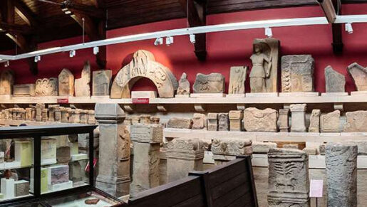
Research, including survey, geophysics and excavation, has shown that the Site contains a wealth of evidential material that forms the basis of our understanding of the frontier’s function and development, its environmental context, and its material culture.
A considerable portion of this evidence has been uncovered by excavation of the Wall (although this still amounts to less than 10% of the whole). A number of milecastles and turrets have also been excavated, along with parts of seven forts. Other excavations in advance of development in the past have also contributed to the body of evidence, along with research excavations at a number of forts where the remains have not been left open for display. This long history of excavations has yielded a huge assemblage of finds; more of them have probably been published here than from any other Roman frontier.
Whilst excavation remains an important research tool, non-invasive techniques, such as analytical field survey, aerial photography, geophysical survey, and Lidar, offers opportunities to locate and to investigate archaeological features. These techniques are also powerful tools in guiding where subsequent research, conservation or protection would be most productive.
Most of the frontier survives as earthworks or as buried archaeology, even in modern urban areas, where major discoveries continue to be made. Un-investigated or undiscovered archaeological deposits have high potential to develop further understanding of the frontier. A Research Framework for Hadrian’s Wall, Frontiers of Knowledge, was published in 2009.
In addition to its exposed and buried structures, the WHS contains a great deal of environmental evidence, All of this has considerable potential to inform future research on the WHS. Environmental evidence may also produce information about the landscape before the construction of the Wall, and the subsequent archaeology of the frontier. In some places – such as Vindolanda and Carlisle – exceptional anaerobic ground conditions has ensured the preservation of a unique collection of objects made from organic materials.
Landscape Value
The geology and morphology of the Hadrian’s Wall landscape directly influenced the location of the frontier and are essential to our understanding of its design and function. Although these are values of the WHS itself, they have also created particular habitats (for both flora and fauna), some of which are subject to statutory designations.
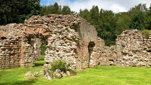
The presence of the Wall has had a lasting effect on the landscape and perceptions of it, and on the evolution of ways of life. The building materials of the frontier have been extensively re-used, and some of the defensive sites provide evidence of continuity or re-occupation (as at Birdoswald or Bewcastle).
Scale
The scale of the planning and construction of the Wall gives an insight into the organisational abilities of the Roman army, in particular the very high level of its skills in surveying, engineering and logistics.
When it was complete, Hadrian’s Wall would have dominated the landscape. Even in its ruined state, its upstanding masonry and earthwork remains are still a significant element in the modern countryside.
Rarity
Hadrian’s Wall is one of the three significant artificial frontiers constructed by the Romans in the reign of the Emperor Hadrian, the most notable period of frontier definition in the history of the Empire (the other two being the German Limes and Fossatum Africae). It is also one of the most concentrated and complex of Roman frontiers. It is unparalleled in the United Kingdom as a large and complex monument.
International Influence
Since the 19th century, research on Hadrian’s Wall has helped to inspire and influence the development of Roman frontier studies in other countries.
HISTORICAL VALUES
Documentation
Hadrian’s Wall is referred to in contemporary Roman accounts. These include the biography of Agricola, by Tacitus, which provides some of the background to the building of the Wall, and Hadrian’s biography which outlines the reason for its construction. Events in Britain that form the background to the creation and operation of the Wall are also alluded to by a number of contemporary historians, including Cassius Dio, Pausanias, and Ammianus Marcellinus.
Numerous inscriptions relating to the construction and occupation of the Wall and its forts have been preserved and recorded over several centuries. The several thousand written documents on wooden writing tablets found at Vindolanda and Carlisle give a direct insight into life in the Roman army on the frontier.
The presence of Hadrian’s Wall was sufficiently notable to be mentioned by Gildas in the sixth century and by Bede in the eighth, and two Walls that probably represent Hadrian’s Wall and the Antonine Wall were shown on a map of Britain drawn in the 13th century by Matthew Paris.
Associative Value
The building of the Wall has a direct link with the Emperor Hadrian, on whose orders it was constructed. Edward Gibbon saw his reign from AD 117 to AD 138 as the central reign of ‘five good emperors‘. Hadrian had a great interest in architecture: the Wall therefore has direct association with a number of other major building projects he initiated or completed during his reign.
The building of Hadrian’s Wall was an element in the Emperor Hadrian’s confirmation of the boundaries of the Roman Empire. The subsequent decline and eventual collapse of the western Roman Empire, recorded at a number of sites on the Wall, created a vacuum in its former borders in which a number of fragmented tribal states evolved.
The remains of the Wall have strong associations with the revival of interest in the classical civilisations and the Romans in particular, expressed both in antiquarian research (really beginning with the 5th edition of Camden’s Britannia, published in 1600), and in the preservation of its fabric and inscriptions. The short section of the Wall at Planetrees saved by William Hutton in 1801 may be the first recorded example of intervention to obtain the preservation in situ of the remains of the Wall. At Birdoswald, in the mid 19th century, Henry Norman, oversaw the excavation and preservation of the fort walls and gates and commissioned paintings by the Richardson brothers of the surviving Roman remains.
Hadrian’s Wall has provided an evocative setting for literature. Part of Rudyard Kipling’sPuck of Pook’s Hill is set on the Wall, which also provided the background to Rosemary Sutcliffe’s children’s book The Eagle of the Ninth, as well as to poems by writers such as W H Auden. In 2001-06, the Writing on the Wall project attracted writers and poets from the modern countries from which the auxiliary units attested on Hadrian’s Wall were originally raised. They expressed their own reaction to Hadrian’s Wall in a published collection.
Hadrian’s Wall has also been used as a setting for a number of films, including Robin Hood, Prince of Thieves (1991), King Arthur (2004), Centurion (2010) and The Eagle (2011). The place of Hadrian’s Wall in the national consciousness is demonstrated by the frequency of references to it in political cartoons and in parlance.
Illustrative Value
The plan to build the Wall and its structures bears witness to the ambition and power of the Roman Empire, and in particular that of the emperor. The building of the Wall was on Emperor Hadrian’s personal instruction, and the decision to abandon it after his death, and to move the frontier northwards to a new wall built across the Clyde-Forth isthmus, was equally an illustration of the authority of his successor, Antoninus Pius.
As part of the FRE, Hadrian’s Wall illustrates the history character and culture of the Roman Empire. The Wall was part of the border of one of the most extensive civilizations in human history which had an important effect on urbanisation and on the spread of cultures among remote regions. The scope and extent of the imperial frontiers reflect the unifying impact of the Roman Empire, an impact that persisted long after the empire had collapsed. The frontiers are the largest single monument to Roman civilization.
The FRE illustrate and reflect the complex technological and organisational abilities of the Roman Empire which allowed it to plan, create and protect a frontier of some 5,000 miles (8,000 km) in length, with a garrison of tens of thousands of men, and to manage the social, economic and military implications. The frontier demonstrates the variety and sophistication of the response to topography and political, military and social circumstances.
AESTHETIC VALUES
The remains of Hadrian’s Wall run through varied landscapes which include two National Parks and an Area of Outstanding Natural Beauty (AONB), the United Kingdom’s highest landscape designations. Taken together, the remains of the frontier and their landscape setting provide a rich aesthetic experience.
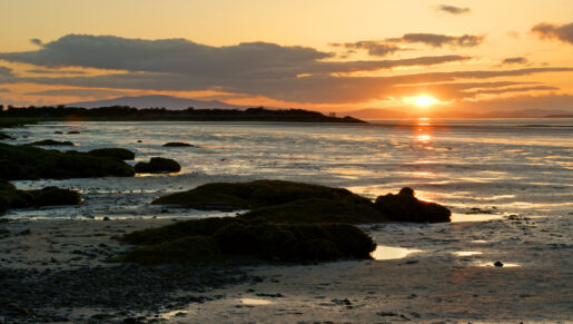
The views across the Solway from Bowness, and as far south as Maryport, are of the Scottish coast, which was not wholly under Roman control, and is dominated by the evocative mountain of Criffel. These views strongly evoke the sensation of being on the edge of the Empire.
In the central section of the Wall, the views to the north are onto a beautiful, wild and tranquil landscape, much of it in Northumberland National Park. The scattered farmsteads blend into the landscape and the managed forests of Wark and Spadeadam form the northern fringe of the Buffer Zone. From the most elevated sections the views extend even further, encompassing southern Scotland and the Solway. To the south the view extends to the North Pennines and to the northern fells of the Lake District. Further east, at Limestone Corner, the views stretch to the Cheviot Hills and into the North Tyne valley. The views of the Wall from the north and the south, and along its length, are also impressive and they help the visitor to appreciate Roman military planning and the relationship of the Wall to the physical and human landscape.
From Chollerford, the frontier at first runs eastwards along ridges of high ground with commanding views north towards the Cheviots and south across the Tyne valley, and continues to the Tyne at Wallsend, ending at Arbeia, overlooking Tynemouth and the North Sea.
The sections of the Wall that were partly rebuilt and capped with turf by Clayton in the 19th century present a different approach to the modern one of conserving the remains as found. They provide a softer visual presentation of the remains, with the faces of the stone now mostly covered in lichens. This has now become a significant element of the monument, conserved in its own right.
A quality much valued on the Wall is that of tranquility, particularly in the areas away from roads and populated areas. It is a vulnerable and fragile value, easily disturbed by intrusions of modern everyday life.
COMMUNAL VALUES
Academic Value
The Site’s value as a resource for the further understanding of both the Wall itself and of Roman frontiers more generally is a very significant one. The long tradition of the study of Hadrian’s Wall that can be traced back to William Camden, has influenced the development of the study of other parts of the Roman Empire and its frontiers. The triennial International Congress of Roman Frontier Studies was established in Newcastle in 1949 and has now grown into a significant archaeological conference with participants from over 30 countries. More broadly, community archaeology programmes have extended participation and enjoyment to new audiences.
The Site’s value as a research resource – set out in the published Research Framework,Frontiers of Knowledge, published in 2009 – includes reconsideration of the records of excavations and surveys, the further study of the visible structures, and of the finds that have been recovered over several centuries. Non-invasive research, using techniques such as geophysics and remote sensing does not require any loss of the archaeological resource.
Because excavation involves the irreversible destruction of archaeological relationships, the accurate recording and dissemination of the results to the widest possible community is essential in order to balance the loss of archaeological deposits with the research value gained through excavation.
The Site also has considerable value for many other academic interests, including pre- and post- Roman archaeology, history, antiquarian history, geology, art and literature studies, natural history, site management, and economic development.
Educational Value
The WHS is an inspirational source of learning for people of all ages, and for formal and informal audiences. The diversity of the garrison and of the associated population along the Wall in Roman times has parallels with that of the UK today, providing important opportunities for engagement and for the promulgation of UNESCO values.
Archaeology and the study of the Romans is the main draw for school groups and university students. Experiences of the Wall cover many subject areas including archaeology, history, citizenship, religious studies, travel and tourism, enterprise, geography, IT, design technology, science, maths, art, English, geology and sustainable development. The many and complex issues related to protecting, conserving and valuing the Wall, and its status as a WHS, provide a wide range of learning opportunities.
Academics, students, schoolchildren, and members of the public have often worked together on excavations and will continue to do so. New research projects facilitate the role of the Wall as a place where ideas and communities meet. The Wall can also be an educational stimulus for creative arts and writing. Community archaeology programmes, such as Wall Quest, on Tyneside, provide ideal links between formal and informal education.
Hadrian’s Wall, together with other already inscribed and prospective sections of the FRE WHS, is emblematic of UNESCO’s aspirations to promote international co-operation in heritage conservation and understanding between different peoples and cultures, through a shared cultural heritage. As such it provides a powerful medium for supporting a range of aspects of educational curricula, in keeping with UNESCO’s remit to support educational activity across the globe, and for wider international cultural exchange. Thus, in the context of FRE, cultural tourism provides wide and important educational opportunities.
Recreational Value
Hadrian’s Wall and its landscape are associated with a variety of recreational activities.
Access to and appreciation of the historic environment is enjoyed by thousands of visitors each year. The Site’s high level of authenticity, its surrounding landscape, and the constant development of its presentation to meet modern expectations, all contribute to its value as a destination for visitors.
As an accessible area with transport links to Tyneside and Carlisle, the beauty of the landscape makes it popular for physical recreation. This is not necessarily linked to visiting the Wall itself, but the open nature of the area makes it popular for walking and cycling, and the faces of the Whin Sill are valued by climbers. The Hadrian’s Wall Path National Trail and the Hadrian’s Cycleway have significantly added to ways of accessing and enjoying the Site.
Social Value
Hadrian’s Wall is internationally known. It is an icon of the north of England, valued by those who live and work in the area as part of their geographic and social identity and as a contributor to the sustainability of local communities.
Those who own and/or manage the land across which the WHS runs have a particularly close association with the Wall. In many cases they are the third or fourth generations of families that have farmed the land, and they have a special pride in the landscape in which they grew up.
Economic Value
The tourism generated by the fame and significance of Hadrian’s Wall, and by facilities such as the National Trail, supports a network of related businesses in a wider corridor, and there is potential for the development of further tourism-related businesses and for the enhancement of the contribution that the WHS makes to the sustainable development of local communities.
Industries in the WHS, and in the Buffer Zone, whose activities may be affected by the existence of the WHS, include agriculture, forestry and quarrying. However, in the urban areas, there are numerous other businesses close to the line of the Wall, which have no direct connection with it, but which may nevertheless benefit from economic regeneration produced by the WHS.
In parts of the WHS the potential benefits from tourism are yet to be fully developed. This is most evident down the Cumbrian coast; the possible inscription of the Lake District as a WHS may offer opportunities for collaboration by which that potential may be unlocked.
NATURAL VALUES
The line chosen for the Hadrianic frontier includes a number of highly valued habitats which are protected by national and international designations which can influence the management of the WHS. For more detail on the nature of the designations, the areas covered and the protected habitats and species can be found here.
Understanding the significance and importance of the World Heritage Site is an important part of the development of a successful management strategy. The values outlined in this section build upon the Frontiers of the Roman Empire SOUV, and look at the values associated specifically with Hadrian’s Wall.
Value takes many forms and can be measured by numerous methods, but aims to identify what Hadrian’s Wall as a monument can tell us, and to illustrate the impact that Hadrian’s Wall has across a broad spectrum of contexts (archaeological, landscape, historical etc).