Hadrian’s Wall Significance
Start Exploring
GERMANY / UNITED KINGDOM OF GREAT BRITAIN AND NORTHERN IRELAND
Brief Synthesis
The Roman Empire, in its territorial extent, was one of the greatest empires history has known.
Enclosing the Mediterranean world and surrounding areas, it was protected by a network of frontiers stretching from the Atlantic Coast in the west to the Black Sea in the east, from central Scotland in the north to the northern fringes of the Sahara Desert in the south. It was largely constructed in the 2nd century AD when the Empire reached its greatest extent. This frontier could be an artificial or natural barrier, protecting spaces or a whole military zone. Its remains encompass both visible and buried archaeology on, behind and beyond the frontier.
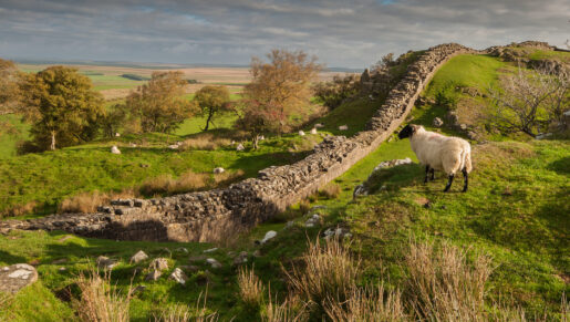
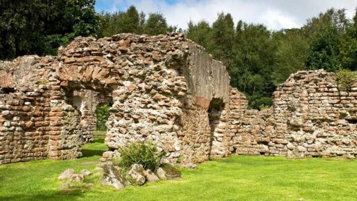
The property consists of three sections of the frontier: Hadrian’s Wall, the Upper German- Raetian Limes and the Antonine Wall, located in the northwestern part of the Empire, constituting the artificial boundaries of the former Roman provinces Britannia, Germania Superior and Raetia: Running 130 km from the mouth of the River Tyne in the east to the Solway Firth, Hadrian’s Wall was built on the orders of the Emperor Hadrian in AD 122 as a continuous linear barrier at the then northernmost limits of the Roman province of Britannia. The frontier extended a further 36km down the Solway coast as a series of intervisible military installations. It constituted the main element in a controlled military zone across northern Britain. The Wall was supplemented by the ditch and banks of the vallum, supporting forts, marching camps and other features in a wide area to the north and south, linked by an extensive road network. It illustrates an ambitious and coherent system of defensive constructions perfected by engineers over the course of several generations and is outstanding for its construction in dressed stone and its excellent use of the spectacular upland terrain through which it passed.
The Upper German-Raetian Limes covers a length of 550 km and runs between Rheinbrohl on the Rhine and Eining on the Danube, built in stages during the 2nd century. With its forts, fortlets, physical barriers, linked infrastructure and civilian architecture it exhibits an important interchange of human values through the development of Roman military architecture in previously largely undeveloped areas thereby giving an authentic insight into the world of antiquity of the late 1st to the mid-3rd century AD. It was not solely a military bulwark, but also defined economic and cultural limits. Although cultural influences extended across the frontier, it did represent a cultural divide between the Romanised world and the non-Romanised Germanic peoples. In large parts it was an arbitrary straight line, which did not take account of the topographical circumstances. Therefore, it is an excellent demonstration of the Roman precision in surveying.
The Antonine Wall was built under the Emperor Antoninus Pius in the 140’s AD as an attempt to conquer parts of northern Britain and extends for some 60 km across central Scotland from the River Forth to the River Clyde. Through its military and civil constructions, it demonstrates cultural interchange through the extension of Roman technical skills, organisation and knowledge to the furthest reaches of the Empire. It embodies a high degree of expertise in the technical mastery of stone and turf defensive constructions. As it was in use for only a single generation, it provides a snapshot of the frontier at a particular point in time and offers a specific insight into how the frontier was designed and built. Together, the remains of the frontiers, consisting of vestiges of walls, ditches, earthworks, fortlets, forts, fortresses, watchtowers, roads and civilian settlements, form a social and historical unit that illustrates an ambitious and coherent system of defensive constructions perfected by engineers over the course of several generations.
Each section of the property constitutes an exceptional example of a linear frontier, encompassing an extensive relict landscape which reflects the way resources were deployed in the northwestern part of the Empire and which displays the unifying character of the Roman Empire, through its common culture, but also its distinctive responses to local geography and climate, as well as political, social and economic conditions.
Criterion (ii): The extant remains of the fortified German Limes, Hadrian’s Wall and Antonine Wall constitute significant elements of the Roman Frontiers present in Europe. With their forts, fortlets, walls, ditches, linked infrastructure and civilian architecture they exhibit an important interchange of human and cultural values at the apogee of the Roman Empire, through the development of Roman military architecture, extending the technical knowledge of construction and management to the very edges of the Empire. They reflect the imposition of a complex frontier system on the existing societies of the northwestern part of the Roman Empire, introducing for the first time military installations and related civilian settlements, linked through an extensive supporting network. The frontiers did not constitute an impregnable barrier, but controlled and allowed the movement of peoples: not only the military units, but also civilians and merchants. Hence, they triggered the exchange of cultural values through movement of soldiers and civilians from different nations. This entailed profound changes and developments in the respective regions in terms of settlement patterns, architecture and landscape design and spatial organization. The frontiers still today form a conspicuous part of the landscape.
Criterion (iii): As parts of the Roman Empire’s general system of defense the German Limes, Hadrian’s Wall and the Antonine Wall have an extraordinarily high cultural value. They bear an exceptional testimony to the maximum extension of the power of the Roman Empire through the consolidation of its northwestern frontiers and thus constitute a physical manifestation of Roman imperial policy. They illustrate the Roman Empire’s ambition to dominate the world in order to establish its law and way of life there in a long-term perspective. They witness Roman colonization in the respective territories, the spread of Roman culture and its different traditions – military, engineering, architecture, religion management and politics – and the large number of human settlements associated with the defences which contribute to an understanding of how soldiers and their families lived in this part of the Roman Empire.
Criterion (iv): The fortified German Limes, Hadrian’s Wall and the Antonine Wall are outstanding examples of Roman military architecture and building techniques and of their technological development, perfected by engineers over the course of several generations. They demonstrate the variety and sophistication of the Romans’ responses to the specific topography and climate as well as to the political, military and social circumstances in the northwestern part of the Empire which spread all around Europe and thereby shaped much of the subsequent development in this part of the world.
Integrity
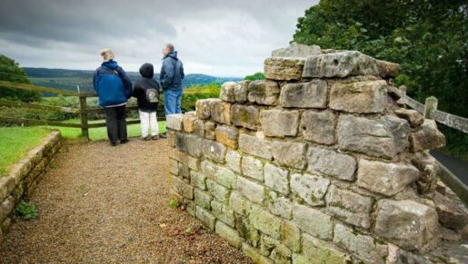
The inscribed components convey the extraordinary complexity and coherence of the Frontiers of the Roman Empire in northwestern Europe. Although some parts have been affected by land use change and natural processes, the integrity of the property is demonstrated through its visible remains and buried archaeological features. Their state of survival has been researched in many areas. Several areas of the frontier have been built over, but where significant archaeological remains have been proven to exist they have been included in the property. About four fifths of the line of Hadrian’s Wall runs through open country. Within the central 45 km of its course, the remains are in an exceptionally good state of preservation, surviving as part of a landscape which still contains significant visible traces of the Roman military presence. Even outside this central zone, many individual sites are well-preserved. As a whole, the Upper German-Raetian Limes is preserved in its historical form. About half of its length is still visible or identical with a current border or way. As with the majority of archaeological monuments, its value lies in the combination of visible earthworks and buried remains. About one third of the Antonine Wall is visible today as a complex series of earthworks and associated structures. Roughly another third lies in open countryside but its line is not visible. The final third lies under urban areas.
Authenticity
The inscribed component parts have a high level of authenticity, with each having been verified through extensive study and research. The materials and substance of underground archaeological remains are well preserved, as are upstanding and visible remains. The form and design of each representative part of the frontier and its associated structures are clear and comprehensible. Later development overlying parts of the frontier are treated as vertical buffer zones. There are a number of reconstructions of elements of the frontier such as forts and watchtowers. Reconstructions since 1965 are not considered as part of the serial property but also act as vertical buffer zones. The form and design of Hadrian’s Wall, in particular its linear character, and its architectural and military elements are still easy to understand and its location and setting in the landscape can be clearly appreciated. Upstanding parts of the property have been conserved in accordance with the highest standards and are in a good state of repair. Much of the Upper German-Raetian Limes is underground, never excavated or backfilled. Excavated parts have then been properly conserved and presented by symbolic delineation above ground protecting their authenticity as well as the setting and integrity of the surroundings. In some cases the authenticity has been compromised by reconstructions erected before the site was inscribed. The remains of the Antonine Wall exist in a generally good condition and visible sections sometimes have significant heights and depths. Conservation and consolidation measures that have been carried out in the interest of better understanding and protection fit in with the setting of the property and do not diminish its authenticity.
Protection and management requirements
At the international level, the States Parties have established an integrated management system consisting of three closely cooperating and interacting bodies: the Inter-Governmental Committee (IGC) to oversee and coordinate the overall management at an international level; the Management Group which assembles those directly responsible for the site management of the property and provides the primary mechanism for sharing best practice; The Bratislava Group, an international advisory body with expert members from States Parties with inscribed or potential parts of the Frontiers of the Roman Empire World Heritage property.
At the national level, each State Party protects its part of the property through appropriate national legislation and regulation. The national management systems address identification and definition of the site’s significance, its conservation, access, the interests and involvement of all stakeholders and its sustainable economic use. Within each State’s Party’s existing legislative and management systems an appropriate management system has been developed, expressed through a regularly updated Management Plan for the identification, protection, conservation and sustainable use of the respective component part.
All parts of Hadrian’s Wall within the World Heritage property are protected by designation under the Ancient Monuments and Archaeological Areas Act 1979 and through the Town and Country Planning Act 1990 and the Planning (Listed Buildings and Conservation Areas) Act 1990 that control planning and development in England. Hadrian’s Wall is also covered by the guidance given in the National Planning Policy Framework 202312 and the National Planning Practice Guidance 2013. Local Plans produced by the local planning authorities on the line of the Wall contain appropriate policies to protect the World Heritage property. The site benefits from other designations such as National Parks, National LandscapesAreas of Outstanding Natural Beauty and the Roman Wall Escarpment Site of Special Scientific Interest. Parts of the property are managed by eight different bodies for public access, but the vast bulk is in private ownership. The Hadrian’s Wall Partnership Board brings together key national and local stakeholders and sets the strategy for the effective management of the property and oversees a network of specialist topic groups.
Within Germany’s federal legal systems, the cultural heritage is protected by the different monuments protection laws of the Länder (Federal States). These ensure protection, promotion, conservation and enhancement of the World Heritage property. All inscribed elements and their buffer zones are respected within the spatial planning system. On the basis of a general Management Plan, detailed Limes Development Plans form the background for actions within each of the Länder. For coordination across the Länder, the Deutsche Limeskommission was founded in 2003. Most parts are in private ownership, but increasing parts are owned by the public.
The Antonine Wall is protected by designation under the Ancient Monuments and Archaeological Areas Act 1979, and through the legislation that guide planning and development in Scotland – the Town and Country Planning (Scotland) Act 1997, the Planning etc. (Scotland) Act 2006 and the Planning (Listed Building and Conservation Areas) (Scotland) Act 1997. It is covered by national policy for the historic environment set out in the Scottish Historic Environment Policy and Scottish Planning Policy. Policies to protect, promote, conserve and enhance the property are included in local authority development plans and strategies, supported by Supplementary Guidance. Most of the Antonine Wall is in private ownership, but some sections are in the care of local authorities and Historic Scotland.